Forecast API - Frequently Asked Questions
How does the &asl parameter affect the weather forecast?
The &asl parameter specifies the elevation above sea level (in meters) for the requested location.
Elevation strongly influences weather forecasts because atmospheric conditions change with altitude. This effect is particularly important in complex terrain, such as mountainous regions.
If the parameter is not provided, the meteoblue API automatically determines the elevation using a digital elevation model (DEM) with a resolution of 80 meters. However, if the exact elevation is known, it is recommended to include it in the API request so that the forecast can be adjusted more accurately.
Changing only the elevation while keeping the same coordinates can significantly alter the forecast. For example, comparing forecasts for Sion, Switzerland, at valley elevation and at 3500 meters shows substantial differences.


Elevation corrections affect multiple forecast variables, including:
- Temperature
- Pressure
- Cloud cover
- Precipitation
- Wind
In mountainous regions, meteoblue high-resolution weather domains adapt forecasts to the surrounding terrain. As a result, a location in a valley can experience very different weather conditions compared with a nearby mountain peak, even when the geographic coordinates are identical.
How is historical data from the forecast API composed?
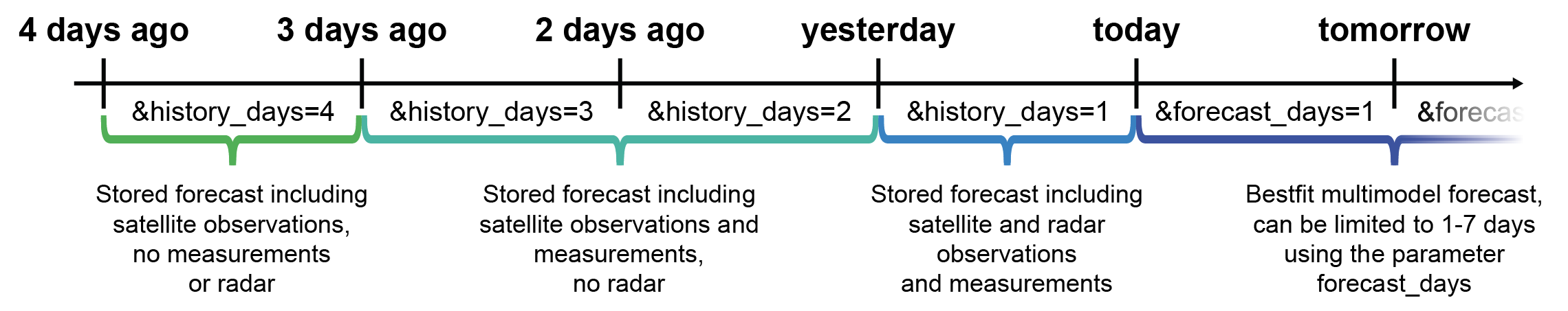
The meteoblue forecast API can provide past forecast data for up to 4 previous days using the parameter &history_days=
Historical data delivered through the forecast API is not a simple archive of model output. Instead, it is progressively refined with additional data sources as time passes.
Depending on how far the requested data lies in the past, different datasets may be incorporated, including:
- Weather observations from ground stations
- Radar measurements for precipitation
- Satellite observations
- Numerical weather model output
- Post-processing and quality control
As time passes, forecast data is gradually enhanced or replaced by observation-based information, improving the accuracy of historical values.